
Climbing and Photography in Peru: That’ll do Donkey!

Peru Part Two:
Finding my feet and lungs in the Peruvian foothills
I was itching to get into the bigger hills and a week and half of ‘lowland acclimatisation treks’, though important, were doing little to satiate my appetite for the objectives that lay a little further away and at a substantially higher altitude. Also my Spanish had improved to such an extent that I could ask my hostel owner (in English) to book me a taxi, donkey and donkey driver to help transport me and my kit to Ishinca Base Camp.
Arriving at the trail head at around 9am, I met Freddie my donkey driver (he was 14 and using his Sunday to help me carry my gear the four hours in to base camp before returning to the trail head to meet his grandad). We trudged slowly uphill for 12kms, gaining around 1000m in altitude to around 4500m, reaching base camp in the early afternoon. After pitching my tent and setting up camp I set about eating, drinking and planning what to do for the next few days.

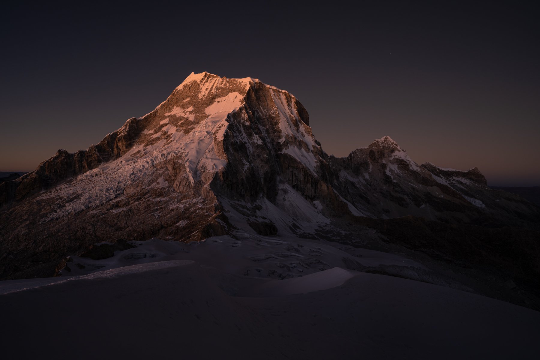
The logical progression according to my pre trip research and talking to people in the refuge at base camp would be to head up to Urus (5495m) first and then Ishinca (5530m) and then look to head to some of the higher objectives on my list. Chatting to one of the helpers in the refuge, he offered to accompany me the next morning as he’d already climbed Urus but hadn’t seen sunrise up there. We left camp at around 1.45am and began the long, tedious shuffle upwards on the unrelentingly steep approach path. Just over an hour later, it was time to don boots and crampons, stash our trainers and continue plodding up above the snowline. My first taste of 5000m was a veritable ass kicking. Burning lungs and legs helped the progress curve take a steep dip. My head felt fine though so progress we did, eventually arriving at the summit as dawn was breaking. We donned all our layers and I took out the tripod and camera and went about firing off shots of the beautiful skies and mountains in every direction. Although smaller than all of it’s neighbours, Urus offered stunning panoramic views of the big peaks to the North, East and South. We sat, slowly succumbing to very cold fingers, but enjoying every minute of my first summit sunrise in the Cordillera Blanca. It also gave me an opportunity to take some photos of the route up Ishinca and of the North Face of Ranrapalca.

Looking North to Copa from Urus Oeste

Urus Central and Este from the summit at sunrise

Looking North from the summit of Urus
Sliding and skidding our way down the snow then the abominable approach path had us back at the refuge in time for some weird brown liquid masquerading as coffee and a short nap in the tent before it became a sauna in the morning sun. The rest of the day was spent in a tired haze as it was too hot to stay in the tent and the flies were too plenty to sleep in the shade of the refuge.
Drinking water and mate de coca, checking out the map and questioning the guides in the refuge helped to confirm my plan to head to Ishinca the next day. A long approach with a good track in through a well filled in and frozen glacier. This made for a lot of time sitting around until midnight the next day but I figured I wasn’t pushed for time and a slowly, slowly attitude at altitude would do me more favours in the long run.
After two long, hot days in base camp, I ate dinner and tried to get some sleep. Being so close to the equator, daylight hours are fairly regular in the Cordillera Blanca and so by 6.30pm it was dark. Despite the favourable light, sleep still wasn’t forthcoming for a few hours. I must have fallen asleep however as my 11.45pm alarm was a pretty unwelcome and disorienting noise. I had forgotten to put my gas cylinder in my sleeping bag, the Jetboil ignition wasn’t sparking for some reason and my lighter was nowhere to be found. Not a good start. A further 20 minutes of trying and I decided breakfast would have to be nuts and an energy bar otherwise I’d miss my summit sunrise timing.
A gentle approach for one and a half hours gave way to the moraine. Two hours and a slight detour later and I was on the glacier about 40 m above where I should have been. Theoretically it would be a simple plod to the summit from here, however I missed the motorway of footprints as I intersected them and went for a bit of a crevasse ridden, avalanche debris covered detour. Realising the error of my ways, I navigated back on to the shoulder as the dawn light was beginning to shine. I hurried up the col to the one section of steepening ice on the whole route and engineered a sheltered spot for myself and my tripod. It was simply a matter of waiting for the shot I wanted, fortunately, due to my late start and my amateur route finding, I didn’t have to wait long.
Ranrapalca at Dawn. One of the potential images that drew me to the Cordillera Blanca

Ishinca summit and Ranrapalca to myself.
The next twenty mins were probably some of the most peaceful I can remember. Watching the light slowly move over Ranrapalca, illuminating it’s East and North Faces with not another soul in sight, witnessing the dance between light and shadow on the glacier below me and slowly losing my fingers and nose to the cold will be something that will stay with me for a very long time. Without wanting to romanticise too much, I think this distils what the mountains mean to me and what I’m searching for when I head into them. It’s not the summit necessarily, or the route, but the places where solitude, serenity and the magnitude of nature collide to create a truly awesome experience.
I packed up and hurried to the top in time for the sun to crest the horizon, spent a few brief minutes taking in the 360 degree panorama, recorded a summit video for my nephew Flynn and then began my descent, down the now well illuminated path across the glacier. I met the first people of the day as I approached the edge of the glacier, feeling very smug for having had the place and the light show to myself. The sun began to warm me and by the time I was back in camp, I was both tired and pretty hot and dehydrated.
After a chilled day in base camp and dinner in the refuge with the guides and their clients, it was time for sleep and then to head back to town. I was up early the next morning, my donkey and driver arrived, we saddled up and sidled back down the 12kms to the trail head where a taxi was waiting to take me back to showers, good food and civilisation. Throughout my five weeks in Peru, the juxtaposition of the relative quiet and tranquillity of the mountains versus the noise and busyness of Huaraz was something I found hard when moving between the two.
I’ve included a link to the routes on the brilliant 3D mapping programme FATMAP. This is invaluable when planning adventures either on the ground or in the air.

Alpenglow on Ranrapalca from Vallunaraju Moraine Camp.

Looking south from a deserted Vallunaraju summit at sunrise.
After another couple of days of the hustle and bustle of Huaraz, I was ready to head for another of my objectives. Vallunaraju at 5686m is a twin peaked mountain very visible from Huaraz. Having seen a video of some friends flying from the summit, I was keen to check out how realistic this was for me. Planning on taking a couple of days with one night at the moraine camp at just under 5000m and then heading up early for the summit and back to town the same day.
Another taxi ride up a long, bumpy road which justifies the beaten up look of most cars in and around town and I was at the trail head, conveniently located next to the refuge with the wild cows from my first post. It was still open so I filled up on some chicken, rice and potatoes and began the steep 2 hr hike up to moraine camp. I arrived at around 1pm and found a family of friends I had met when on Urus and Ishinca. It was nice to catch up with them and while away the afternoon hours in the sun reading and taking in the view. A quick jaunt up to the glacier entry point to suss the route for the following morning, followed by cooking dinner and watching the sunset and it was time for bed (6.45pm). Unfortunately, it was Saturday night and apparently people come to moraine camp to drink beer and party. A couple of hours later and a few unsubtle hints from other climbers in the camp and the revellers turned their music down enough for sleep to become a real possibility.
I had forgotten to set my alarm so waking at 2.15am when I had intended to leave by 2am led to a barrage of expletives mumbled in the direction of the party and a hectic few minutes trying to make sure I was first out of camp. This also meant breakfast was the Peruvian equivalent of a Timeout and I only had 500ml of water with me.
Surprisingly, something clicked and I moved pretty well, reaching the summit in time for dawn and sunrise. Although little more than a snow plod at altitude, it was still the highest I had been to that point and it was good to see I was adapting well to life above 5000m. Racing back down to camp, I passed two of the family I had met previously. The father and his daughter at 10 years old were laughing and joking their way up seemingly as though this was all being played out at sea level. It was great to see her so psyched for me to have summited and realise that she’d be there soon too. We bumped our mitt clad fists and went on our way.
I felt pleased with a round trip of five hours from moraine camp on just 300ml of water and a handful of Peruvian Haribo. It’s amazing what the body can cope with when it’s synced with desire. All that remained was the 500m of steep dust to descend and the taxi back to town for more pizza and crepes.
Below is the link to my route from moraine camp on FATMAP.